Dave Feineman
Community Project Participation

Local Community Part 150 Study Group
Rocky Mountain Metropolitan Airport

Community Focus Group
June 10, 2025
Initial Meeting
The Community Member Focus Group had its first meeting on June 10th.
This is just a summary of some of the key points from the meeting
The FAA is the ultimate decision maker for any recommendations about airport noise
These Part 150 Noise Studies generally take 2 to 2.5 years to complete. A major part of the timeline is the time reserved for the FAA to review the study and recommendations.
Consultants have been retained to perform the AEDT noise modelling- the only noise measurements that the FAA recognizes as being valid. The consultants are also collecting and doing ground truth on current land use surrounding the airport.
The Part 150 Study is:
o Undertaken voluntarily by the airport
o Its results can be used to obtain FAA funding for noise mitigation recommendations
· The Part 150 Study is not:
o A way to close of limit the use of the airport
o A way to address air quality concerns related to aircraft exhaust emissions
o A way to shift noise from one community to another
Given the constraints of such studies, the types of options to address airport noise could include changes to operational procedures, residential sound proofing improvements, and land acquisition within high
Link to the Part 150 website
July 10, 2025
6:00 PM - 7:30 PM
Omni Interlocken Hotel
Centennial Ballroom
500 Interlocken Boulevard
Broomfield, CO 80021
This event has already occurred
First public open house on the Part 150 Noise Study
Find out what the Part 150 Noise Study is
The study goals and needs
Project Phases
How to stay informed
Link to Denver ABC 7 report on the meeting by Claire Lavezorio
April 1, 2026 Status Update Meeting
Summary
This is my overview of the consultant’s work to date on RMMA airport operations and their associated noise impacts on the surrounding communities. Forecasting for future airport usage has been completed and approved by the Federal Aviation Administration (FAA), with noise contour mapping—emphasizing areas that exceed the 65 dB threshold—anticipated for presentation by the end of April. The study remains bounded by an FAA methodology, and its data analysis is constrained by longstanding regulatory thresholds.
Background
The first meeting of the Community Members Focus Group was held last year and dealt with the process and methodology of performing a Part 150 study that meetings FAA requirements. This next meeting was a status update and a discussion of the inputs to the AEDT computer noise modeling tool.
Current Status
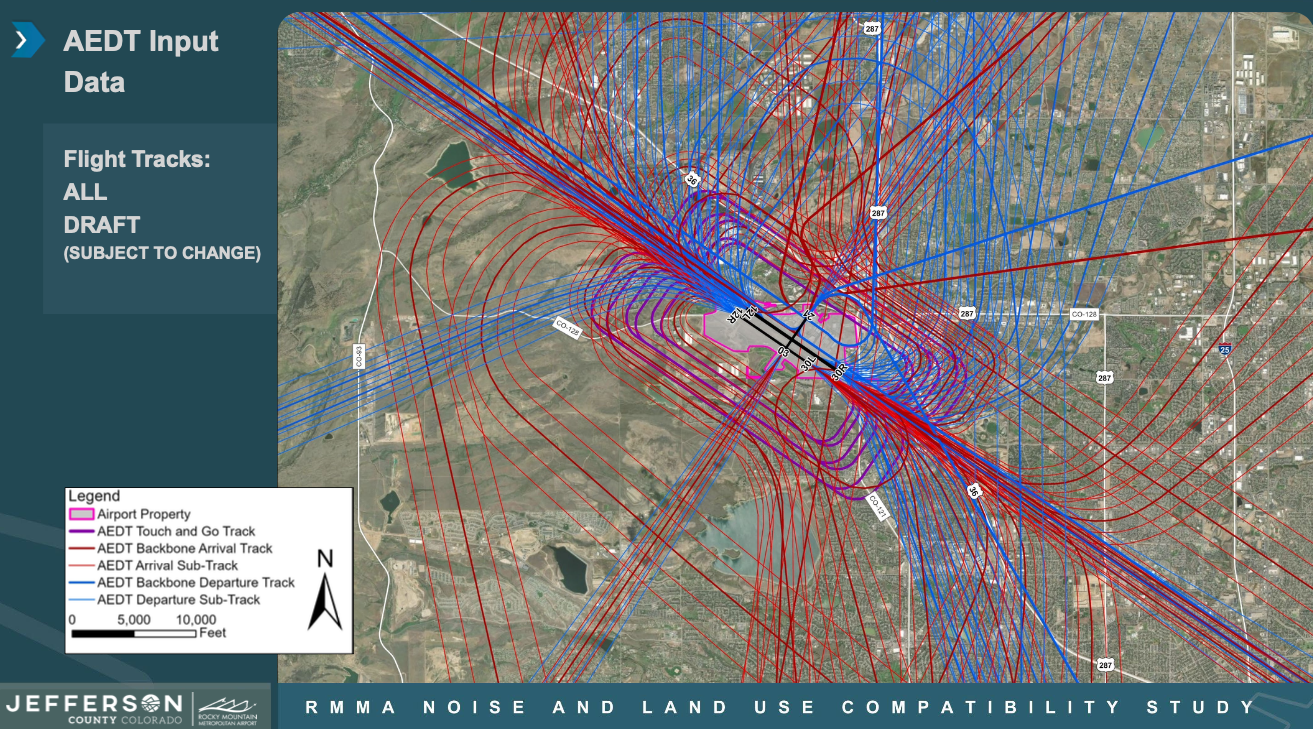
Work is continuing for noise modeling, which requires topographical and meteorological data, flight tracks, airport activity forecast, and understanding of the mix of aircraft using the airport.
Work on forecasting of future airport use appears to be complete and accepted by the FAA
The noise contour mapping to show noise levels in the vicinity of the airport, highlighting the areas above the 65 dB level criteria used determine impacted areas is expected to be ready for presentation at the end of this April
The noise contours will be overlaid on top of land use maps –I suspect that the data they collected for Ward 2 for areas that have seen recent development activity may be incomplete or out of date based on the sample shown in the meeting
The forecast data shown in the meeting would say that from 2024 to 2031, they are expecting an annual growth in airport traffic of 1.7%. In 2026 they expect a total number of aircraft operations of 305,558 and by 2031 it will grow to 331,408
They already have flight path maps that show arrival and departure patterns for each of the runways. A ton of data to dig into here- but for example one of the backbone arrival paths for runway 12L (in their data appendix called 12LAP9) goes right over Skyestone and is primarily used by turboprop aircraft landing at night. As would be expected, touch and go training flights follow an inner, middle, and outer track all of which go over Superior, Skyestone, & Westminster on the southwest side of the airport, or Superior, Lac Amora, and the Broomfield Industrial Park areas on the northeast side of the airport. The composite of all flight paths clearly show that most of the backbone paths going to and from RMMA traverse most of Broomfield: aircraft overflights are not just a Skyestone issue, although the touch and go activity dominated by piston aircraft flights is much more localized in the CCoB for areas close to the airport.
You may be aware that the FAA mandated flight pattern changes last year, which have been identified separately in the study.
Airport Related News Articles
FAA Mandated Flight Path Changes
Airport Noise Article from the Daily Camera Newspaper
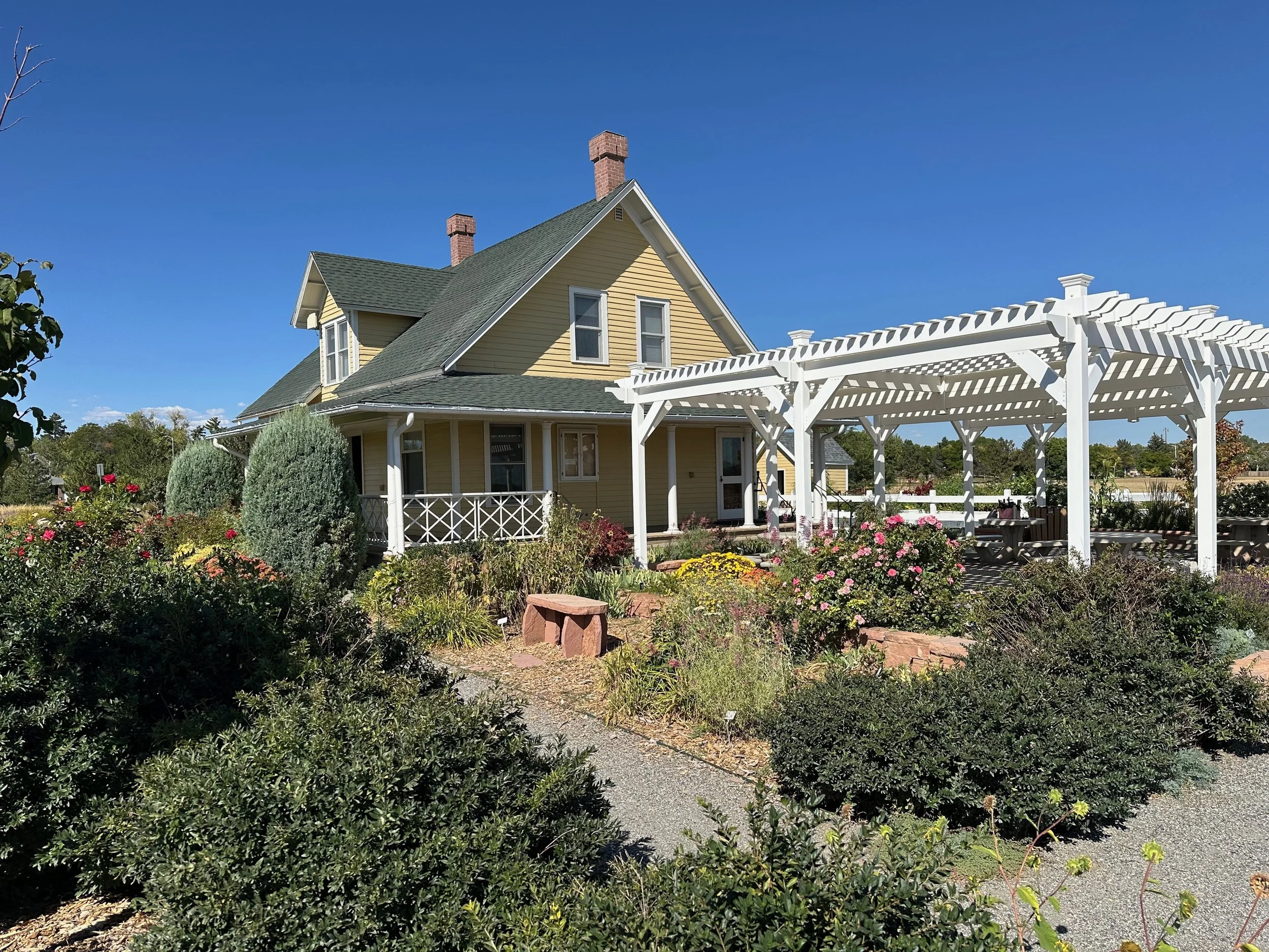
Broomfield Historical Society
What We Do
Our organization promotes Broomfield’s history through projects and activities including
Educational programs & lecturesx
Historic sites tours
Historic occasion celebratyions
Publications including the Broomcorn Express
Support for the Broomfield Depot Museum
Community outreach

History Colorado sponsored events and activities can be found here
USA 250 /
Colorado 150
Events are underway for the 2026 250th anniversary of the USA and 150th anniversary of Colorado statehood.
Locally we have an initiative called Brooomfield 2026! which will also have events commemorating the 65th anniversary of the founding of the city of Broomfield, and the 25 years of the City and County of Broomfield’s creation.
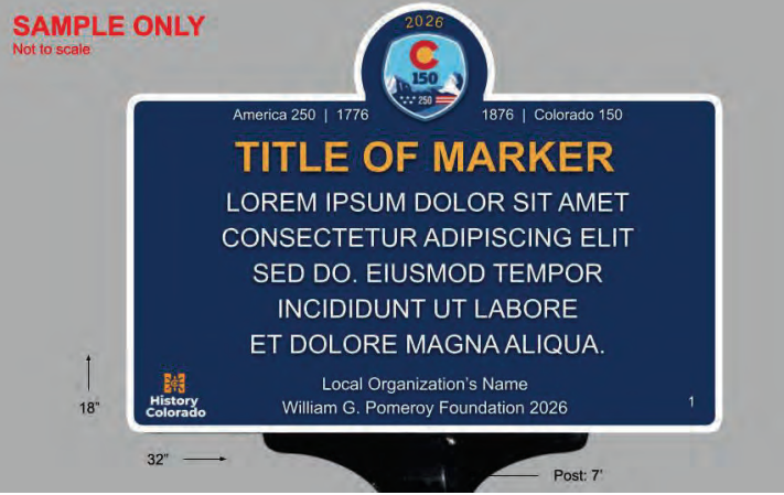
History Colorado has launched their Historic Markers: History Where It Happened program. It is a legacy program that will run for 7 years and is intended to put up 150 new signs. The cost of the signs is supported by a grant from the Pomeroy Foundation from New York, which costs their fabrication and shipping. Local installation and maintenance of signs is not included in the offer. They emphasized that this is a crowd sourced program that is expecting submissions from non-academic sources. Signs being selected for implementation will be evaluated based on regional representation of historic markers and on bringing forward stories that emphasize less represented voices and experiences.
Work has begun to develop materials for an August, 2026 submission of signage options for Broomfield. Among the options being considered are:
Proposed Marker 1 Historic person
Mary Meikle Wright (1852-1921)
Proposed Marker 2 Historic person
Gleb Aleksander Ilyin (1889-1968)
Proposed Marker 3 Historic event
Trainwreck of 1958
Proposed Marker 4 Historic Location
Jones Hall
Proposed Marker 5 Historic Location
Great Western Reservoir
Proposed Marker 6 Historic Location
Lakeview Cemetery
Broomfield Ideas for the Colorado Historic Markers Program
Some of my local history publications
-
-
-
The area where Broomfield currently sits was on the edge of the Western Interior Seaway during the Cretaceous Period about 65 million years ago. The seaway ran from the arctic to the Gulf Coast, and its beach provided a natural migration path for the dinosaurs up to the time when they bacame extinct. This article deals with the geology of the area, the environment where these rocks were deposited, and the types of fossils associated with them.
The Broomcorn Express Volume 5.1
June, 2025
https://broomfieldhistoricalsociety.org/june-2025-dinosaurs-of-broomfield/
-
Broomfield Historical Society · Sep 30, 2024
The County of Broomfield is a recent creation, only dating back to 2001. Much of Broomfield’s development is associated with the construction of the Broomfield Heights subdivision in the mid 1950s, but it should be obvious that people lived and worked here well before that time. This article is an attempt to provide a bit of an overview of the places—where yesterday is still on view—that provide historical context of the development of the area over time, focusing on public and commercial structures.The County of Broomfield is a recent creation, only dating back to 2001. Much of Broomfield’s development is associated with the construction of the Broomfield Heights subdivision in the mid 1950s, but it should be obvious that people lived and worked here well before that time. This article is an attempt to provide a bit of an overview of the places—where yesterday is still on view—that provide historical context of the development of the area over time, focusing on public and commercial structures.
-
Broomfield Historical Society · Jun 30, 2024
Improved transportation access by rail was an important factor in the transformation of Broomfield, Colorado from a sparsely populated agricultural area to a more formally recognizable town. Somewhat surprisingly, the introduction of trains and interurban service was accompanied by significant wrecks and accidents which continued into modern times associated with diesel locomotives, electric signals, and radio communications. This article deals with many of the known incidents and what lessons they may have for us today associated with the potential reintroduction of passenger service over the same line between Denver and Boulder.
-
The Broomcorn Express, Quarterly Publication of the Friends of Broomfield History · Apr 1, 2024
Traces the development of the Great Western Reservoir in Broomfield, Colorado from its creation as a source of irrigation water for large farms along the Front Range into a municipal water supply, and the impacts of environmental contamination leading to its present day use as a source of non-potable irrigation water.
-
The Broomcorn Express · Jan 1, 2024
A short article on local history, and how it differs from news reporting. It specifically focusses on the importance of oral history collection in a location like Broomfield, Colorado which might have not seemed particularly newsworthy in earlier times.A short article on local history, and how it differs from news reporting. It specifically focusses on the importance of oral history collection in a location like Broomfield, Colorado which might have not seemed particularly newsworthy in earlier times.
FOR MORE INFORMATION